In an unusual story the NPWS reports a prosecution for the poisoning of birds in nearby county Meath: "The Minister for the Environment, Heritage and Local Government John Gormley T.D. has today (30/4/2009) welcomed the successful outcome to a prosecution taken by the National Parks & Wildlife Service (NPWS) of his Department in Navan District Court on Wednesday 22nd of April 09.
In November 07, Conservation Ranger Annette Lynch investigated a complaint of dying rooks in a field at Headfort Demesne. She found dead and dying rooks and bread laced with a blue substance in a recently tilled field. As she collected the rooks and bait she was challenged by a man, who appeared to be the landowner. When she identified herself and told him what she was doing he stated that he was not the landowner, had no interest in the land and refused to give his name and address. She took his registration number and traced it to defendant. She brought the rooks and bait to the University Veterinary Hospital, UCD for analysis."
This recalls a similar story some time ago involving the destruction of a rookerie in which the Louth Ranger, Kieran Buckley, successfully brought a case against a Louth resident, the conviction being upheld on appeal with a reduction in the fine.
Hopefully this zealon the part of NPWS rangers will spread to the rest of the country and we wil get successful prosecutions of the individuals responsible for poisoning White-tailed Eagles in Kerry and Golden Eagles in Donegal. To support this see the petition in this link.
Friday, May 1, 2009

Friday, April 10, 2009
Floodplains for Development?
According to the Fourth Assessment Report of the UN International Panel on Climate Change, sea levels will rise by between 18 cm to 59 cm by 2100, however this estimate is limited to the thermal expansion of water and only gives limited consideration to the effect Antarctic and Greenland ice sheets melting.

Sea level rise over the last 150 years
However a recent climate change conference in Copenhagen, covered in the New Scientist , warns that the currently observed rise of 3mm per year is far above what was predicted in the TAR:
"Because modelling how the Greenland and Antarctic ice sheets will react to rising temperatures is fiendishly complicated, the IPCC did not include either in its estimate. It's no small omission: the Greenland ice cap, the smaller and so far less stable of the two, holds enough water that if it all melted, it would raise sea levels by 6 metres on average across the globe."
According to John Church of the Centre for Australian Weather and Climate Research, "By 2100, sea levels could be 1 metre or more above current levels".
Presumably responding to this, FG Cllr Eamonn O'Boyle warned in last weeks Argus that "a rise of one metre or more in global sea levels would be quite disastrous in itself, as all low-lying areas such as most of Dundalk, would be threatened by catastrophic flooding if this recent authoritative prediction materialises."
Cllr O'Boyle's solution is to enable a local developer to raise the dykes between Soldiers Point and Blackrock by 2 metres; in exchange the developer would be granted permission to develop the floodplain for housing and other uses.
The Independent newspaper notes that "Britain's Environment Agency was apparently unique when it discarded the IPCC's 2007 advice as flawed. Based on its own estimates, it is planning flood defences for 2100 on the basis of a one-metre rise in sea levels – with a "worst-case scenario" of 2.7 metres."
Countering Cllr O'Boyle's comments, Paraic McKevitt, a County Council candidate for the Green Party, was quoted in the same newspaper, "'Climate change and rising sea levels are very critical issues facing low lying coastal communities around Dundalk Bay. What we need is a Dundalk Bay flood protection plan and not a one-off embankment that leaves one development dry while increasing the flooding risk for everyone else," referring to the phenomenum whereby strengthening sea defences in one area can have knock-on effects on other areas.
According to the Office of Public Works the cause of past flooding events in the area has been due to rainfall swelling the rivers Ramparts, Blackwater, and Fane, as well as, or combined with, high tides and storm surges.
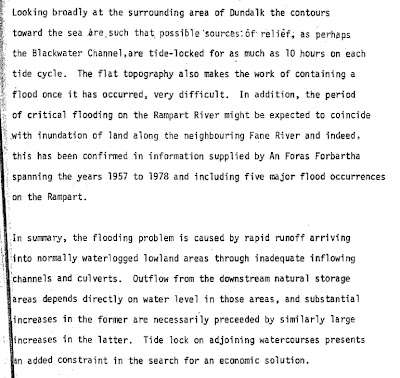
Extract from OPW report
The advice given by the OPW in regard to development on floodplains, on their special web site is unequivocal:
"Impact of flood risk on development Locating development in an area at risk from flooding can lead to property damage, human stress and hardship, problems obtaining property insurance and consequential demands for the expenditure of local authority or central government resources on flood protection works. The construction of protection works either at the time of the development, or at a later date, will incur additional costs, may not provide absolute immunity from the risk of flooding and can, if not appropriately designed, have detrimental effects on flood risk elsewhere. "
It continues:
"Impact of development on flood risk upstream In times of flood, the river flows not only through its normal channel but also along the flood plains. Any constriction of the natural flow path can 'back-up' the river and lead to increased flood levels upstream. The construction of buildings or houses, and particularly embankments for infrastructure or protection, in or across a floodplain can therefore not only put the development itself at risk of flooding, but can also increase the flood risk for land and properties upstream. The same is obviously true of any construction in, or encroachment into, the normal river channel. "
And finally,
"Impact of development of flood risk downstream Natural or agricultural land, such as forests, woodland, pastures or crop fields, is normally able to absorb a considerable proportion of any rain that falls onto it. Covering such land with buildings, tarmac (such as for parking areas or roads), or other impermeable materials significantly reduces this ability to absorb rainfall, and will lead to increased land runoff. As a result, large developments, including those away from major rivers, can increase river flows and the risk of flooding to land and property downstream. A number of smaller developments built up over a period of time can have the same effect.
Impact of tidal flood risk on development A combination of high tides, waves, high winds and surges developed from low-pressure systems can lead to extensive flooding. Current predictions of climate change indicate that the risk of flooding from the sea will increase in the future. Any area below current or predicted future peak sea levels, including areas behind existing defences that offer only a certain level of protection, are at risk from flooding in the future."
The debate on how Dundalk, and indeed County Louth, should respond to rising sea levels is joined - we look forward to following how it develops!

Sea level rise over the last 150 years
However a recent climate change conference in Copenhagen, covered in the New Scientist , warns that the currently observed rise of 3mm per year is far above what was predicted in the TAR:
"Because modelling how the Greenland and Antarctic ice sheets will react to rising temperatures is fiendishly complicated, the IPCC did not include either in its estimate. It's no small omission: the Greenland ice cap, the smaller and so far less stable of the two, holds enough water that if it all melted, it would raise sea levels by 6 metres on average across the globe."
According to John Church of the Centre for Australian Weather and Climate Research, "By 2100, sea levels could be 1 metre or more above current levels".
Presumably responding to this, FG Cllr Eamonn O'Boyle warned in last weeks Argus that "a rise of one metre or more in global sea levels would be quite disastrous in itself, as all low-lying areas such as most of Dundalk, would be threatened by catastrophic flooding if this recent authoritative prediction materialises."
Cllr O'Boyle's solution is to enable a local developer to raise the dykes between Soldiers Point and Blackrock by 2 metres; in exchange the developer would be granted permission to develop the floodplain for housing and other uses.
The Independent newspaper notes that "Britain's Environment Agency was apparently unique when it discarded the IPCC's 2007 advice as flawed. Based on its own estimates, it is planning flood defences for 2100 on the basis of a one-metre rise in sea levels – with a "worst-case scenario" of 2.7 metres."
Countering Cllr O'Boyle's comments, Paraic McKevitt, a County Council candidate for the Green Party, was quoted in the same newspaper, "'Climate change and rising sea levels are very critical issues facing low lying coastal communities around Dundalk Bay. What we need is a Dundalk Bay flood protection plan and not a one-off embankment that leaves one development dry while increasing the flooding risk for everyone else," referring to the phenomenum whereby strengthening sea defences in one area can have knock-on effects on other areas.
According to the Office of Public Works the cause of past flooding events in the area has been due to rainfall swelling the rivers Ramparts, Blackwater, and Fane, as well as, or combined with, high tides and storm surges.

Extract from OPW report
The advice given by the OPW in regard to development on floodplains, on their special web site is unequivocal:
"Impact of flood risk on development Locating development in an area at risk from flooding can lead to property damage, human stress and hardship, problems obtaining property insurance and consequential demands for the expenditure of local authority or central government resources on flood protection works. The construction of protection works either at the time of the development, or at a later date, will incur additional costs, may not provide absolute immunity from the risk of flooding and can, if not appropriately designed, have detrimental effects on flood risk elsewhere. "
It continues:
"Impact of development on flood risk upstream In times of flood, the river flows not only through its normal channel but also along the flood plains. Any constriction of the natural flow path can 'back-up' the river and lead to increased flood levels upstream. The construction of buildings or houses, and particularly embankments for infrastructure or protection, in or across a floodplain can therefore not only put the development itself at risk of flooding, but can also increase the flood risk for land and properties upstream. The same is obviously true of any construction in, or encroachment into, the normal river channel. "
And finally,
"Impact of development of flood risk downstream Natural or agricultural land, such as forests, woodland, pastures or crop fields, is normally able to absorb a considerable proportion of any rain that falls onto it. Covering such land with buildings, tarmac (such as for parking areas or roads), or other impermeable materials significantly reduces this ability to absorb rainfall, and will lead to increased land runoff. As a result, large developments, including those away from major rivers, can increase river flows and the risk of flooding to land and property downstream. A number of smaller developments built up over a period of time can have the same effect.
Impact of tidal flood risk on development A combination of high tides, waves, high winds and surges developed from low-pressure systems can lead to extensive flooding. Current predictions of climate change indicate that the risk of flooding from the sea will increase in the future. Any area below current or predicted future peak sea levels, including areas behind existing defences that offer only a certain level of protection, are at risk from flooding in the future."
The debate on how Dundalk, and indeed County Louth, should respond to rising sea levels is joined - we look forward to following how it develops!
Friday, March 27, 2009
Planning Matters
It looks like the Quinn Energy application to the EPA for an IPPC license for the operation of the proposed power plant at Toomes is once again deferred, this time up until 29th of May 2009. However persons wishing to make a submission should make it as soon as possible to the EPA.
The quarry at Bush in Cooley County Louth (Dundalk Quarry Products Ltd.) has applied to massively extend the quarry, the planning reference is 09/96 and is currently being considered by the County Council.

Quarry at Bush, Cooley.
Another application with significant consequences for Louth's environment is application reference 09/22 - this application describes "Permission for dumping and spreading of soil and stone waste for the benefit of agricultural activity and all associated site works at Stonetown Lower and Redbog, Dundalk, Co. Louth." The County Council kicked this application back for further information. The applicant was requested to provide a Biodiversity Impact Assessment and to investigate possible archaeological artifacts in the area.

Lower Stonetown and Red Bog, the area can clearly be seen as high quality from the aerial shot with superimposed OS map.
Another application sent for Further Information, this time in the south of the county along the banks of the Boyne, is 08154 (Drogheda Borough). This application proposes to develop a high quality ecological area along the north banks of the Boyne to the west of Drogheda. It is currently unclear when a decision will be made on this one...

The quarry at Bush in Cooley County Louth (Dundalk Quarry Products Ltd.) has applied to massively extend the quarry, the planning reference is 09/96 and is currently being considered by the County Council.

Quarry at Bush, Cooley.
Another application with significant consequences for Louth's environment is application reference 09/22 - this application describes "Permission for dumping and spreading of soil and stone waste for the benefit of agricultural activity and all associated site works at Stonetown Lower and Redbog, Dundalk, Co. Louth." The County Council kicked this application back for further information. The applicant was requested to provide a Biodiversity Impact Assessment and to investigate possible archaeological artifacts in the area.

Lower Stonetown and Red Bog, the area can clearly be seen as high quality from the aerial shot with superimposed OS map.
Another application sent for Further Information, this time in the south of the county along the banks of the Boyne, is 08154 (Drogheda Borough). This application proposes to develop a high quality ecological area along the north banks of the Boyne to the west of Drogheda. It is currently unclear when a decision will be made on this one...

Tuesday, March 10, 2009
Dundalk Flood Defense
In a headline article in last weeks Dundalk Leader, a proposal to raise the existing dyke by a further three metres from the Soldiers Point area to Blackrock was described. This proposal centres around the Rockview Farm and the idea is to create a large area protected from flooding that can be developed for housing, amentites, commercial development etc. According to the piece, "...the developers of Rockview Farm, a 200-acre site rezoned in 2003 may find it possible to convince Dundalk Councillors that the added protection provided to the townby a proposed upgrade to the embankment makes the plan worthwhile."
This proposal is just the latest in a series of efforts to get permission to develop this area. In 1994 an application was made to put a golf course and housing in the area. Earlier an application was made for a a business park and associated amenities. Both these and other applicaiton to develope the low-lying flood plain were refused by the County Council for the very good reason that the whole area regularly floods.

The proposal to increase the height of the dyke by 3 metres may protect the immediate area but as with many coastal developments, there is an inevitable knock-on effect: unless the dyke were to stretch all the way up the Castletown river the dyke would only move the flood plain into the centre of Dundalk!

The current thinking on such flood plains is that they should not be developed but rather left to absorb the impact of flooding events. In the south of England and in Holland, where flooding is a major problem, the current thinking is to retreat from the coast in an approach called "managed retreat". Furthermore, sea levels have been slowly rising for more than 100 years now, and with global warming, are likely to rise even further with flood events becoming more common, making the proposition to erect this dyke even less likely to be approved.
Tuesday, March 3, 2009
Vandalism
In a story reported in the Argus, Paraic McKevitt, who is rumoured to be running for the Green Party in the upcoming County Council elections, complained about a recent spate of vandalism in Greenore village: "Residents in Greenore woke last Thursday morning to find that shrubs which had been planted at the entrance to the village's famous golf course had been pulled up by vandals." This kind of petty vandalism is increasingly a feature, not just of the big towns in Louth, but increasingly the smaller towns and villages. "People have put in a lot of time and effort to try and improve the appearance of the village so it's very disappointing when something like this happens," said McKevitt.
This theme was taken up by the Lordship and Cooley Community Alert AGM in a previous item in the Dundalk Democrat: "High on the agenda is the ongoing concern on crime in the area and the continuing efforts to counteract it. Chairman of the group Kevin Conroy said "As recent reports in the press indicate, there are few signs that the problem is being resolved. Indeed, many crimes both petty and otherwise are not even being reported" he added. " Indeed failure to report and highlight these petty crimes and anti-social behavior is often the cause for their perpetrators to graduate to bigger crimes as they grow older.
We can expect more of this kind of thing as the economy continues to decline. According to a piece in the well respected OpEd News: "Around the world, law enforcement officials and sociologists are closely watching the current economy-driven rise in crime. Domestic violence, robbery, theft and murder are rising, as people fail to cope with job loss, repossession and uncertainty. In Ireland, as in the United States, economic problems are generating a fertile field for domestic violence. "
This theme was taken up by the Lordship and Cooley Community Alert AGM in a previous item in the Dundalk Democrat: "High on the agenda is the ongoing concern on crime in the area and the continuing efforts to counteract it. Chairman of the group Kevin Conroy said "As recent reports in the press indicate, there are few signs that the problem is being resolved. Indeed, many crimes both petty and otherwise are not even being reported" he added. " Indeed failure to report and highlight these petty crimes and anti-social behavior is often the cause for their perpetrators to graduate to bigger crimes as they grow older.
We can expect more of this kind of thing as the economy continues to decline. According to a piece in the well respected OpEd News: "Around the world, law enforcement officials and sociologists are closely watching the current economy-driven rise in crime. Domestic violence, robbery, theft and murder are rising, as people fail to cope with job loss, repossession and uncertainty. In Ireland, as in the United States, economic problems are generating a fertile field for domestic violence. "
Thursday, February 19, 2009
Toomes Raider Thwarted

Wet woodland at Toomes - lives to fight another day!
According to a piece in The Argus this week Quinn Energy plans to build a gas-fired power plant in the Ballykelly/Toomes area near Louth village are on hold. According to a spokesman for the troubled Quinn Group, "the company is still in the middle of the permitting system and timelines for reconstruction have been put back."
Quinn originally applied to An Bord Pleanala for planning permission under the Strategic Infrastructure Act in September 2007. After several delays and an extended oral hearing the Inspector refused permission on the grounds that the plant was a material contravention of the County Development Plan - the implication being that the Coundy Development Plan never intended such a vast commercially-run industrial facilityto be located in such a agriculturally-based rural area. However the Bord overruled their own inspector and the opinions of the many objectors and approved the plant with a large number of conditions. Approval was given in May 2008, well beyond the normal 28 week delay between application and approval.

Toomes wet meadow slated for destruction by Quinn
Quinn then applied to the Environmental Protection Agency to obtain an Integrated Pollution Prevention Control permit but the EPA inspector requested a considerable amount of further information from the applicant - delays in providing this information is the cause of the current delay.
Having said that one has to wonder if the economic downtown, the credit crunch and Quinn's well known problems in relation to the Anglo Irish Bank scandal are not adding to Quinn's problems.

Common Spotted Orchid (alba form) at Toomes
The 30 acre area in question is acknowledged by Quinn as being of very high ecological quality in the EIS that was submitted as part of the ABP application. It consists of an area of wet woodland and wet meadow, habitats that are rare in County Louth. If the project ever does go ahead the area will be substantially destroyed and County Louth's environment will be much the poorer for it. Given the many alternative brownfield sites that would be just as suitable, but probably more costly than "an auld bog", one has to wonder what the words "sustainable" mean in terms of the missions of both the EPA and An Bord Pleanala!
Friday, February 13, 2009
Eco-tourism, Wind and Wave, and Smart Logistics
These were the themes of the Sustainability Conference Hosted by the Dundalk Chamber of Commerce last Tuesday.
The first session covered opportunities for the exploitation of sustainable energy sources in the form of wind and wave. The presentation from Open Hydro was particularly impressive in terms of "big solutions", while the presentation from Cool Power addressed home solutions. The fact that we will very soon able to sell home generated energy back to the ESB was not lost on the Chamber audience.


The second session focused on integrated eco-tourism opportunities in County Louth. The first, by Brendan McSherry, Louth Heritage Officer covered, our amazing bird life; Dundalk bay has the biggest concentration of overwintering birds in the country. Yet the county, unlike every other county on the east coast, has no infrastructure for accessing nature at all! It also outlined the possibility of designating a Geopark in the Cooleys and Gullion comples. The second talk, from James Orr of Castle Espie, made a convincing case for how integrated infrastructure for nature watching can be profitable in itself, not to mention the many spinoffs from such resources. The last presentation in that session described the Marble Arches Geopark in Fermanagh/Cavan, giving a taste of how a Geopark could work in Louth.

The final session dealt with Dundalk's potential as a national logistics hub, much more familiar fare for the assembled be-suited businessmen and women.
The first session covered opportunities for the exploitation of sustainable energy sources in the form of wind and wave. The presentation from Open Hydro was particularly impressive in terms of "big solutions", while the presentation from Cool Power addressed home solutions. The fact that we will very soon able to sell home generated energy back to the ESB was not lost on the Chamber audience.


The second session focused on integrated eco-tourism opportunities in County Louth. The first, by Brendan McSherry, Louth Heritage Officer covered, our amazing bird life; Dundalk bay has the biggest concentration of overwintering birds in the country. Yet the county, unlike every other county on the east coast, has no infrastructure for accessing nature at all! It also outlined the possibility of designating a Geopark in the Cooleys and Gullion comples. The second talk, from James Orr of Castle Espie, made a convincing case for how integrated infrastructure for nature watching can be profitable in itself, not to mention the many spinoffs from such resources. The last presentation in that session described the Marble Arches Geopark in Fermanagh/Cavan, giving a taste of how a Geopark could work in Louth.

The final session dealt with Dundalk's potential as a national logistics hub, much more familiar fare for the assembled be-suited businessmen and women.
Subscribe to:
Posts (Atom)